

Binsted's village, countryside and majestic woods, and its peace and tranquillity, could be lost forever to future generations. Highways England are holding a consultation about the Arundel Bypass (lasts till 16th October). One of its three ‘options’, called 5A, passes through Binsted - dividing and destroying this beautiful, still intact and united landscape.
The damage
The Binsted option version of the A27 Arundel Bypass first destroys ancient woodland near Yapton Lane and The Oaks, at Hundred House Copse, cutting through an Iron Age earthwork. Crossing Binsted Lane south-eastward south of Sandyhole Pond, it severs four houses from the village - three cottages at Foxes Cottages, and further on, Binsted Manor near the Madonna pond. On the way to Binsted Manor it crosses the central fields of Binsted, the setting of Binsted Woods, passing close to St Mary’s church, Church Farm and five other listed buildings. It destroys Walberton Action Group’s plantings of 2005 (new hedges with trees, and some stand-alone trees), including the Old Scotland Lane hedge laid by local and Park volunteers in 2015-16. It passes on a high embankment through Binsted Park, the historic parkland within the south part of Binsted woods; three houses there would be very close to it. This landscape is beloved of walkers from the villages and further afield for its tranquility and ancient character; both of which would be shattered.
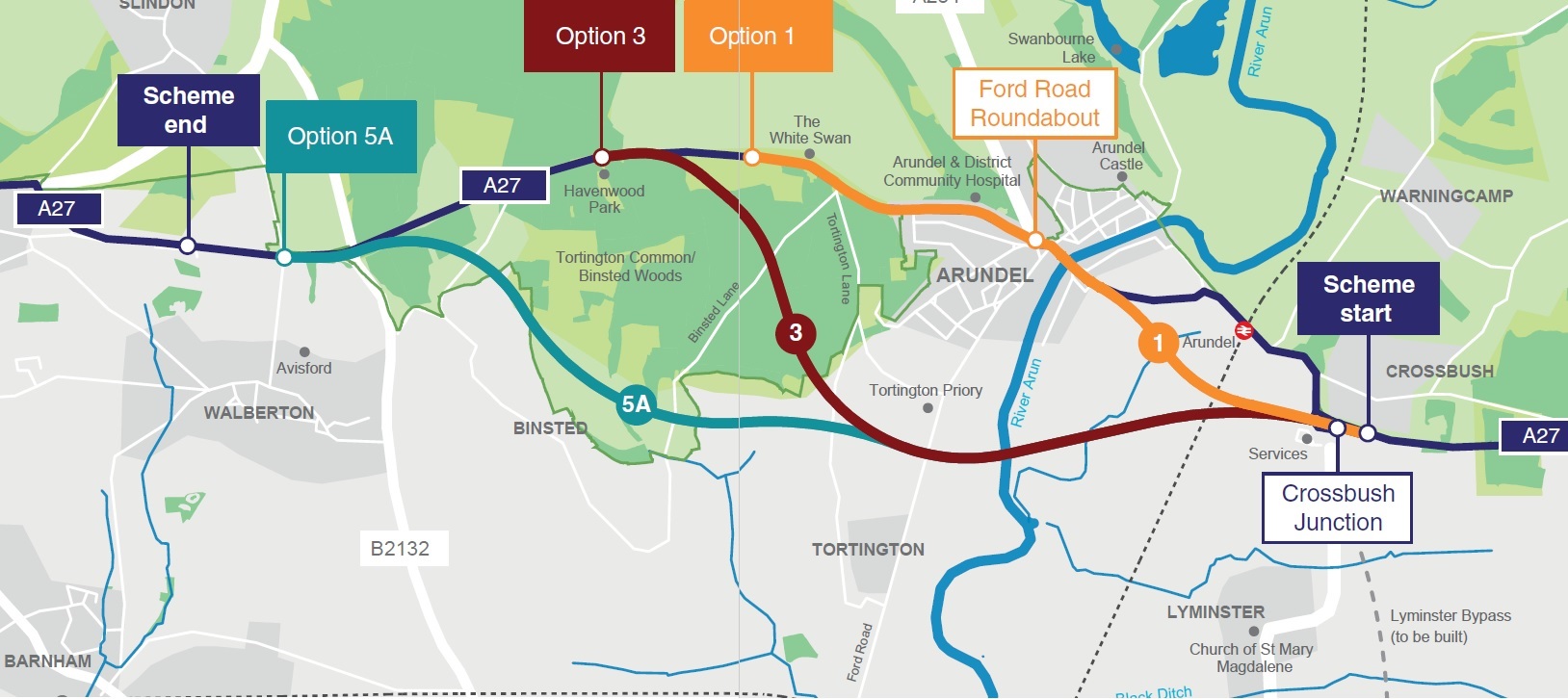
The Arundel Bypass options in Highways England’s Consultation, 2017
The consultation favours the Binsted route, because of mistakes and distortions
The other two options are Option 3 (the old Pink-Blue route) and Option 1 (mostly online with a new bit of road south of Arundel station). Routes similar to 3 and 5A were compared in 1992 and 3 was chosen. Binsted Woods, said in the 1992 comparison to be ‘nationally important’, are ignored and downgraded in the new consultation. Their character, as 250 acres of broadleaved woodland, different from the recovering conifer plantation on Tortington Common, is never made clear.
The Ancient Woodland designation, meaning areas that have been woodland since 1600, are now more protected in planning law, may be Binsted’s undoing. It does not give protection to areas such as the ‘non-Ancient’ parts of Binsted Woods, although they are just as species rich as the ‘Ancient’ parts, or more so - whereas the whole of Tortington Common counts as Ancient Woodland.
Highways’ reports are contain many other distortions and extraordinary mistakes. A photo captioned ‘Binsted Park’ is of a tarmac road on Tortington Common. Parts of Binsted Woods – because not ‘Ancient’ - are shown as white space instead of woodland on maps of the routes. New ‘cost benefit’ figures look unbelievable. The supposed ‘benefit’ for the Binsted route has gone up by 71 per cent since 2015 without explanation. Wildlife surveys used are out of date.
These and other distortions could make people think the Binsted route is the best route.
Consultation exhibitions are happening as far away as Littlehampton, Bognor and Storrington. Those people may know nothing about Binsted. If you love Binsted and Binsted Woods, go to one of the Consultation venues, or take part via the Internet, vote for one of the other options or something different, and tell Highways why you object to Option 5A. Tell people about the distortions described in this article.
Details of the consultation are on www.highwaysengland.citizenspace.com/he/a27-arundel-bypass. An ‘unmanned’ exhibition about the consultation is at Walberton Pavilion on Monday 9 October from 2 to 8 pm. For more information and a petition to sign, see www.arundelbypass.co.uk.